Recent blog posts
- Reih Bleeaney Vanannan Award 2025 - Isle of Man’s Highest Cultural Honour
- Who Was St Patrick?
- 'The Deer's Cry' Illustrations by Archibald Knox
- Winter Solstice at Newgrange Ancient Passage Tomb
- Israel to close Dublin embassy as Ireland continues stand for peace in Gaza
- Ireland will act on International Criminal Court Warrant to arrest Israeli Prime Minister Benjamin Netanyahu
- ICC issues arrest warrants for Israeli Prime Minister Benjamin Netanyahu and former Defence Minister Yoav Gallant
- Wooden Celtic 2,600-year-old burial chamber uncovered in southern Germany
- Largest, most comprehensive, Archibald Knox exhibition and events ever held in the world
- Pope Calls for Immediate Ceasefire in Gaza and Lebanon
Visit us on Facebook
And on Twitter
And on Youtube
Shapinsay
Burroughston Broch
Surrounded by a grass mound this broch is located on the island of Shapinsay. The island is reached by car ferry from Kirkwall to Balfour and the broch is in the northeast of Shapinsay about a mile south from the Ness of Ork. As the exterior has not been excavated it is possible to look down into the broch where the remains of stone furniture and a complete chamber can be seen. Also on the island is Mor Stein standing stone in the southeast and south east of Mor Stein is Castle Bloody Souterrain. In the southwest of Shapinsay is Balfour Castle built in 1847 by the architect David Bryce on the site of an older building.
Image: Burroughston Broch, Shapinsay image © Copyright C Michael Hogan licensed for reuse under Creative Commons Licence.
Rousay
Rousay is about two miles north from Mainland island. It is an island of considerable archaeological importance with many historical sites. It can be reached by car ferry from Tingwall on Mainland.
Brinian
In the south of the island is home to the Ferry Terminal in Rousay and the arrival point from Tingwall. At the terminal there is a small Heritage Centre which gives information on Rousay's archaeology and history. It is open throughout the year.
Taversoe Tuick
This is a Neolithic chambered tomb located west from the Ferry Terminal along the B9064. The cairn is a round mound containing two chambers one below the other. When excavated the lower chamber had the remains of at least three people one a crouched skeleton on a stone shelf. Other cremated remains were in the passageway. In the upper chamber further cremated remains were found. There is another miniature chamber outside of the cairn.
Blackhammer
This is a Neolithic chambered tomb the remains of which are protected by a modern roof. It is located further west along the coastal road from Taversoe Tuick and the footpath to the site is signposted. When excavated the chamber had seven compartments in which were two human and other animal remains along with fragments of Neolithic pottery.
Knowe of Yarso
This Neolithic cambered tomb was in use about 2900BC. When excavated the remains of about twenty-seven people were found, seventeen of which were the skulls only. The remains of animals and flints and pottery fragments were also found. It is the highest of the Rousay tombs and is located north of the B9064 coast road and on a ridge after a signposted walk.
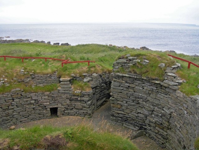
Midhowe Broch
This is on the west Muckle Water in Rousay on the coast overlooking Eynhallow Sound toward Mainland. It is estimated that is was built and in use between 200BC and 200AD. The circular wall of the broch is about four metres in height and the interior was divided into two by the use of large stone slabs and then further divided into smaller units. The remains of other later dwellings can be seen outside of the broch.
Midhowe Chambered Cairn
This is a communal tomb dating to about 3500BC. When the excavation took place twenty-five peoples remains were discovered. Within the tomb were also two other burials from a later period along with animal bones. The cairn is over seventy-five feet long and divided into twenty-five compartments. The site is covered by a large shed for protection with internal walkways that allow you to look down on the tomb. It is located close to Midhowe Broch in Rousay.
Yetnasteen Standing Stone
This stone is over seven feet high and is located in northeast Rousay. Northeast from Faraclett farm.
Celtic nation:
- Scotland
Itinerary:
- Scotland Orkney Islands
Place type:
- Ancient site


