
Recent blog posts
- Reih Bleeaney Vanannan Award 2025 - Isle of Man’s Highest Cultural Honour
- Who Was St Patrick?
- 'The Deer's Cry' Illustrations by Archibald Knox
- Winter Solstice at Newgrange Ancient Passage Tomb
- Israel to close Dublin embassy as Ireland continues stand for peace in Gaza
- Ireland will act on International Criminal Court Warrant to arrest Israeli Prime Minister Benjamin Netanyahu
- ICC issues arrest warrants for Israeli Prime Minister Benjamin Netanyahu and former Defence Minister Yoav Gallant
- Wooden Celtic 2,600-year-old burial chamber uncovered in southern Germany
- Largest, most comprehensive, Archibald Knox exhibition and events ever held in the world
- Pope Calls for Immediate Ceasefire in Gaza and Lebanon
Visit us on Facebook
And on Twitter
And on Youtube
Cruggleton Castle
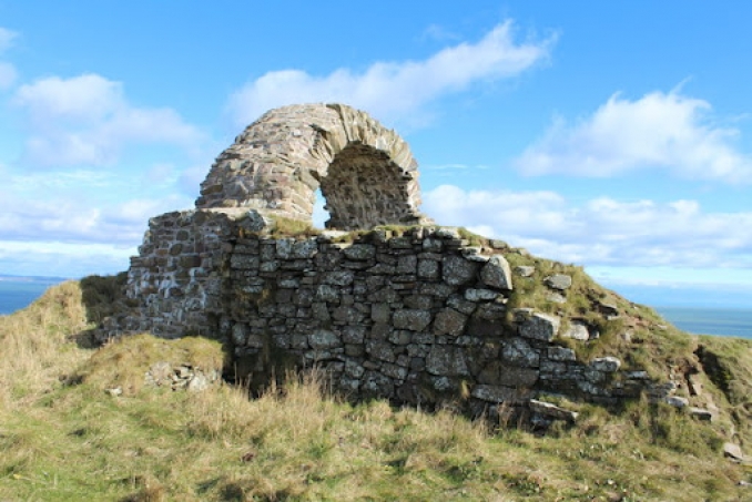
Cruggleton Castle ruins are located at Cruggleton Point, in the Machers Penisula in southwest Scotland. It stands on the 130 feet high cliff edge of a promontory around 3 miles east of Whithorn (Scottish Gaelic: Taigh Mhàrtainn) and just under four miles south-east of the village of Sorbie, Wigtownshire, Scotland (Scottish Gaelic: Soirbidh, Siorrachd Bhaile na h-Ùige, Alba). The earliest stone tower and curtain wall was built between the late 13th and early 15th centuries. This was on the site of a previous motte and a timber tower. Excavations have revealed that the site on which it stands has been used for many centuries and the remains of a late Iron Age hut circle was discovered.
Cruggleton Castle is accessible along a coastal path from Galloway House and is known locally as 'The Arch' due to a distinctive feature of the ruin clearly visible from the nearby B7063 Garlieston to Isle of Whithorn road. The remains that can be seen today include a narrow section of barrel vaulting in what was the tower and part of the curtain wall. The foundations of a number of other buildings can be seen across the site. The outline of the motte remains visible, measuring around 102ft by 95 ft, as is a broad ditch across the promontory, about 160 ft west of the ruins. It is thought Cruggleton was once the residence of the Earls of Galloway.
Link and Image: The Douglas Archives - Cruggleton Castle and image is courtesy of their website.
Celtic nation:
- Scotland
Itinerary:
- Scotland Dumfries & Galloway
Place type:
- Castle


