
Recent blog posts
- Reih Bleeaney Vanannan Award 2025 - Isle of Man’s Highest Cultural Honour
- Who Was St Patrick?
- 'The Deer's Cry' Illustrations by Archibald Knox
- Winter Solstice at Newgrange Ancient Passage Tomb
- Israel to close Dublin embassy as Ireland continues stand for peace in Gaza
- Ireland will act on International Criminal Court Warrant to arrest Israeli Prime Minister Benjamin Netanyahu
- ICC issues arrest warrants for Israeli Prime Minister Benjamin Netanyahu and former Defence Minister Yoav Gallant
- Wooden Celtic 2,600-year-old burial chamber uncovered in southern Germany
- Largest, most comprehensive, Archibald Knox exhibition and events ever held in the world
- Pope Calls for Immediate Ceasefire in Gaza and Lebanon
Visit us on Facebook
And on Twitter
And on Youtube
Kilmalkedar - Cill Maoilchéadair
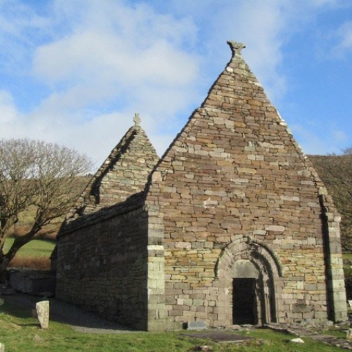
Kilmalkader (Irish: Cill Maoilchéadair) Cill Mhaoilchéadair - Kilmalkedar is medieval monsatic site located on on the Dingle Peninsula, (Irish: Corca Dhuibhne). It is about 3 miles (4.8 km) east of the village Ballyferriter (Irish: Baile an Fheirtéaraigh) and just over 4 miles (6.7) km northwest of the town of Dingle (Irish: Daingean Uí Chúis) and just over 1 mile (2km) due east of An Mhuiríochin in County Kerry (Irish: Contae Chiarraí). This ecclesiastical site once stood on the pilgrimage route, Cosán na Naomh - the Saints’ Path, which makes its way to Mount Brandon. On the site are the ruins of a church dating to the 12th-century which is noted for the carvings that can still be seen, including on the doorway and on the chancel arch. The church was still in use until the 16th century.
There are a number of old carved stones on the site that pre-date the church. Near the chancel arch is the Alphabet Stone, which has been dated to the 6th century AD. Within the graveyard are a number stone monuments. The ogham stone which is estimated to date from the 5th or 6th century. It has the inscription ẠṆM MẠỊLE-INBIR MACI BROCANN (‘the name of’ [or ‘the soul of’] ‘MAILE INBIR the son of BROCANN’). Unusually for ogham stones there is a hole in the top. There is a carved sundial thought to date from 8th or 9th centuries AD. A large Latin cross in the graveyard is thought to date to the same period as the construction of the church in the 12th century.
Link: Ireland's Dingle Peninsula Corca Dhuibhne - Kilmalkedar Church Cill Maoilchéadair.
Image: Kilmalkeder Church image courtesy of The Dingle Peninsula
Celtic nation:
- Ireland
Itinerary:
- Ireland Munster west
Place type:
- Religious


