Recent blog posts
- Reih Bleeaney Vanannan Award 2025 - Isle of Man’s Highest Cultural Honour
- Who Was St Patrick?
- 'The Deer's Cry' Illustrations by Archibald Knox
- Winter Solstice at Newgrange Ancient Passage Tomb
- Israel to close Dublin embassy as Ireland continues stand for peace in Gaza
- Ireland will act on International Criminal Court Warrant to arrest Israeli Prime Minister Benjamin Netanyahu
- ICC issues arrest warrants for Israeli Prime Minister Benjamin Netanyahu and former Defence Minister Yoav Gallant
- Wooden Celtic 2,600-year-old burial chamber uncovered in southern Germany
- Largest, most comprehensive, Archibald Knox exhibition and events ever held in the world
- Pope Calls for Immediate Ceasefire in Gaza and Lebanon
Visit us on Facebook
And on Twitter
And on Youtube
Fetlar
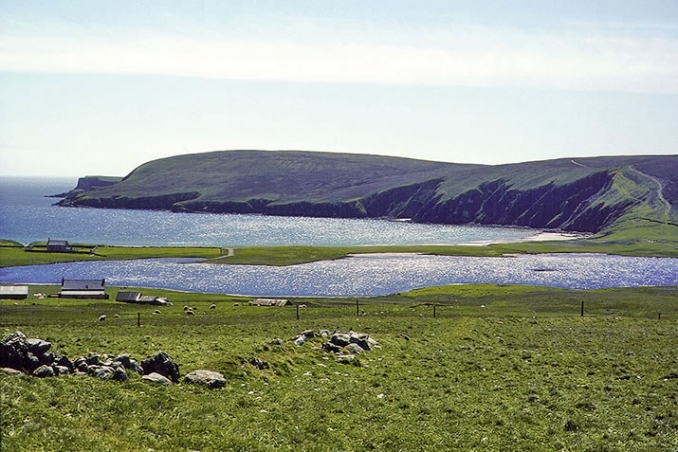
This is an island east from Yell and covers an area of about sixteen square miles. A wall known as the Funzie Girt or Finnigirt Dyke runs across the island from north to south, with the northern section being the most complete and is thought to date from Mesolithic or Neolithic times. The island has been inhabited at least since the Neolithic period and through into Pictish and Norse times until the present day. The ferry to Fetlar goes from Gutcher in Yell to Hamars Ness in Fetlar, sometimes via Unst. Petrol for motor vehicles needs to be obtained before arrival at Fetlar.
Hjaltadans
This is a stone circle located midway across the island north of Skutes Water. The circle is not the most accessible. The 36 stones stones are low in the grass and are about 37 feet in diameter. There is an earthen ring inside the outer one with two stones in the centre.
Fetlar Interpretive Centre
This is a community run museum with exhibitions (including interactive computer presentations) on history, archaeology, folklore and wildlife. It is located at the Beach of Houbie in the south of the island. The centre is open from 11am-3pm Mon-Fri and 1pm-4pm Sat-Sun.
Link and Image: Fetlar-Shetland image courtesy NorthLink Ferries.
Celtic nation:
- Scotland
Itinerary:
- Scotland Shetland Islands
Place type:
- Natural


